Chewelah Creek Bank Stabilization with Concrete Blocksby Charles Kessler, Rick Schumaker, and Keitlyn Watson |
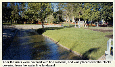
 The City of Chewelah Park, located in Chewelah, Washington, is a high recreational use area. Chewelah Creek flows through the park and is often the focal point of the recreation experience. The park is located in a natural depositional area and the creek bottom has been aggrading over time. This has resulted in increased bank erosion in several portions of the park, channel widening, and imminent loss of the few trees along the creek bank. In the past, the city has used concrete sidewalk slabs to stabilize areas of increased erosion. These were used in part because any smaller material was removed from the banks by recreationists and used to make temporary dams across the channel. The city had also tried planting woody vegetation in some areas, only to have the material removed by park users. The city was looking for a way to stabilize the streambanks in the high recreation areas of the park, while not degrading the recreation experience by restricting access to the creek. The 1994 Chewelah Creek Watershed Management Plan identified sediment from degraded streambanks as a major threat to water quality within the watershed. During the development of the plan, the Watershed Management Committee (WMC) commented on the use of concrete sidewalk slabs to stabilize the streambanks in the city park. Many of the committee questioned the effectiveness of the slabs and were concerned with the potential hazard these rough surfaces presented to those using the creek, particularly children. The city was encouraged to replace the slabs with something that would provide bank protection and access to the creek and not be a hazard to people using the park. As the lead agency on the implementation of the Chewelah Creek Watershed Management Plan, the Stevens County Conservation District began discussing the possibility of a stabilization project in the park with the City of Chewelah in 1996. After consultation with the NRCS State Engineer, Bill Erion, the idea of using interlocking, open-celled concrete blocks on top of geotextile material was presented to the city. The blocks would be built into mats that could be covered with coarse material under the water surface and with topsoil and sod above the water line. The mats would provide bank protection, while still allowing access to the creek. The District applied to the Washington State Conservation Commission for funding to conduct the bank stabilization project in the park. The original proposal called for planning during 1997 and actual implementation of the project in the low flow period of 1998. These plans changed after the creek flooded the park in the spring of 1997, leaving an ever-widening channel and a large portion of the area covered with coarse sediment. One tree was lost due to erosion. The city was forced to conduct rehabilitation work in the summer of 1997. It was determined that the placement of concrete mats would be best conducted in conjunction with this rehabilitation in order to minimize the overall disturbance to the park. Information was obtained on the various types of concrete products available for such an application. It was decided that an interlocking, open-celled block that could be constructed in mats would be best suited for the park. The open-cell configuration presented the best design for achieving the city's goal of planting sod over the top of the blocks. Several meetings were held in the park with NRCS state watershed staff, the city and representatives of all the agencies that might be involved in providing permits for such a project: Ecology, the Washington State Department of Fish and Wildlife, the U.S. Army Corps of Engineers, and the Stevens County Planning Department. With the current emphasis on use of bioengineering techniques, concerns were expressed that this project did not fit into that category. The city emphasized that this is a recreation area and that unlimited creek access was a major concern. The city had used bioengineering techniques previously downstream of the park and will use them in portions of the park where the creek does not receive heavy use. These techniques resulted in good bank stabilization, but the dense vegetation excluded easy access to the creek. A State Environmental Policy Act checklist was prepared for the project. A Hydraulic Project Approval was received from the Department of Fish and Wildlife, with the stipulation that work in the creek be completed by September 15, due to the spawning season for German brown trout. Use of a coffer dam and turbidity curtain structure was approved for diverting flow and trapping sediment in the work area. District staff worked with the Colville NRCS field office to survey the work area. Of concern was a box culvert under a street at the downstream end of the area. The bottom of the culvert would be the controlling factor in the vertical placement of the mats. Mats close to the culvert would ideally be placed in the channel so that the bottom edge would be at least 1.5 feet below the bottom of the culvert to account for possible degradation of the channel bottom. A public meeting was held prior to the project to inform the City Council, Planning Commission and general public of the project. The meeting included a review of the planning process and a visit to the project site. A request for bids was published and distributed to interested suppliers. The city had decided to build the mats on site using crews from the Airway Heights Correctional Facility located near Spokane, Washington, so the bid was to cover the blocks, cables, fasteners, geotextile material and shipping. The successful bidder was Pacific Erosion Control of Seattle. They agreed to supply Amorflex CL 30 cellular concrete blocks, 1/4" diameter Duravet polyester cable and Nicolon 40-10 fabric. The bid price for 10,500 square feet of block, 15,000 feet of cable and 1200 square yards of geotextile material was $49,000. John Bates of Pacific Erosion Control came to Chewelah for the first three days of the project to provide technical assistance in mat construction and placement. The City of Chewelah provided the equipment and crews for preparing the site and placing the mats. The correctional facility crews built mats, filled sandbags, constructed flow diversions and sediment traps, and placed topsoil and sod over the mats. Site preparation involved digging a trench in the channel bottom approximately 10 feet from the shoulder of the bank and then shaping the bank to the desired slope for the mat placement. A number of concrete slabs were removed during the shaping process. In high recreation use areas, a bank slope of at least 3:1 was used. In other areas, such as on curves, bank slopes ranged from 1.5:1 to 2.5:1. The bottom of the trench was established at such a depth that the lower edge of the mat would be a minimum of 1.5 feet below the channel bottom. On the upstream end of the project, a trench was dug perpendicular to the channel in order to bury the upstream edge of the mat to a greater depth. Larger material was used to bury the mat in this trench in order to prevent scouring under the mat. A trench was also dug so that the top side of the mat could be buried approximately one foot to provide additional anchoring. Geotextile material was spread on the prepared slope, taking care to have the lower blocks sitting on fabric. Mats were constructed on a street adjacent to the park. The majority of the mats were 8 feet wide by 15 feet long. Special use mats ranged from 4 to 7 feet wide, while maintaining the same length. Mats were transported to the streambank using a Case 621B loader equipped with a boom attachment and a spreader bar (provided by Pacific Erosion Control). In places with limited access for the loader, such as under bridges or around large trees, mats were constructed by hand in the water. On curves and around obstructions, partial blocks and grout were used to fill in voids. To apply grout in the water, concrete was placed in a locking plastic bag, the air expelled, and the bag sealed. The concrete then conformed to the area to be filled without being exposed to the creek.
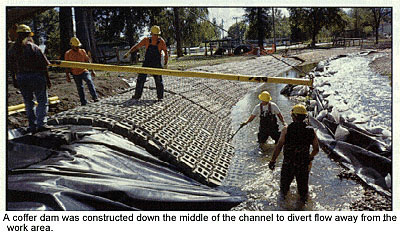
The total project involved placing mats on 300 feet of one bank and 380 feet of the opposite bank. The banks of Chewelah Creek, in the southern end of the park, are stable and the sod has provided a very nice recreational area. The channel cross section for higher flows has been increased while the low flow channel is narrower and deeper. Bank erosion was leading to the development of a wide, shallow channel in this portion of the park. Use of a coffer dam down the center of the channel lead to the development of a mid-channel ridge. Removal of the dam did not create enough velocity to redistribute this material. An excavator with a 6 foot blade attached to its bucket was used to move this material from the center of the channel to the sides. The material in the channel bottom and streambanks made it very difficult to create the desired slopes. Material would not hold a steep slope and would slump into the channel trench. Coarser material was often used to develop the slopes needed for the placement of the mats. With the heavy emphasis today on bioengineering, this project received negative comments from some parties. This approximately 400 foot section of the creek has been a high use recreation area for quite some time. There has been little or no spawning, rearing, resting, or hiding habitat for fish in this reach in the past several years. The reach provides fish passage between areas of better habitat, such as the root wad project location, just upstream. The city has worked to improve habitat downstream and will, in the next year, be conducting projects to improve the habitat upstream. L&W For more information, contact Stevens County Conservation District, 232 Williams Lake Road, Colville, WA 99114, (509)685-0937, fax (509)684-1982. |
©2000, 1999, 1998 Land and Water, Inc.