Watershed Dike Protects Richland Centerby Bob Oertel |
 Folks living in Richland Center, Wisconsin, no longer spend anxious days and sleepless nights when heavy rain storms fill the Pine River. Now, thanks to the Pine River Watershed project, the sometimes-raging river flows harmlessly past this town of 5,000 residents. Some 11,000 feet of earthen dikes keep overflow waters from spreading across a third of the town, including the downtown business section and the adjoining residential area. As recently as 1992, the town was essentially "closed down" by a 25-year frequency flood, followed two days later by an 80-year flood. A long time Richland Center homeowner eagerly voices a widespread opinion about the success of the project. "Even though many of us had some real questions in the beginning, we're convinced now that this is the best thing that could have happened to Richland Center." Flood Control Started Upstream Over the years, farmers have cropped the floodplain and pushed their crop fields and pastures up the sides of the adjoining once-forested hillsides. These slopes, once uncovered and cropped, suffered serious erosion. Early in the 1940's, the Richland County and the neighboring Vernon County Soil and Water Conservation Districts, (SWCDs) in which the Pine River watershed is located, began encouraging landowners to apply soil and water conservation practices. Technical assistance for this conservation land treatment was provided to the Districts by the Soil Conservation Service (SCS). SCS was renamed the Natural Resource Conservation Service (NRCS) several years ago. The conservation practices applied by landowners over the first 35 years did much to control erosion and protect the land within the Pine River Watershed. By 1969, a total of 447 (58%) out of a total of 776 farm units had voluntarily applied conservation measures. Erosion had been reduced to an annual soil loss of 4.1 ton per acre. This reduction was commendable but was not considered enough. Despite the protection of the upper watershed achieved by the various land treatment practices, there still remained the problem of flooding downstream. Recognition of the flooding problem, and the need for still more land treatment upstream, led to the development of the comprehensive Pine River Watershed Project under the authority of the Watershed Protection and Flood Prevention Act (PL566, 83rd Congress). The Richland County and the Vernon County SWCD's sponsored the project. Their application to the Secretary of Agriculture for approval of a plan of work and technical and financial assistance was approved in May, 1976. The project included watershed protection, flood prevention, recreational development, and fish and wildlife improvement. Participation by Richland Center was a "natural" because at different times at least a third of the city had suffered serious damage from flooding. Laverne Hardy, during his terms as Mayor in the '60's, recognized this problem and "started the ball rolling" towards the ultimate solution by the watershed project. The succeeding mayor, Darlo Wentz, continued the city's involvement, working tirelessly to gain and maintain relationships with the numerous local, state and federal agencies and organizations. Accelerated Land Treatment The wide range of practices applied included small, on-farm floodwater-retarding structures, grade stabilizing structures, agricultural waste management and conservation cropping systems, contouring, diversions, minimum tillage, strip cropping, critical area planting, grass waterways, ponds, fencing wood lots, livestock crossings on streams, logging road and skid train erosion control, pasture and hay land planting and management, streambank protection, tree planting, timber stand improvement and wildlife upland habitat management. The land treatment portion of the watershed project was completed in 1988. It reduced the peak discharge of a 100-year flood 3,000 cubic feet per second (CFS) at Richland Center (from 19,200 to 16,200).
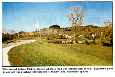
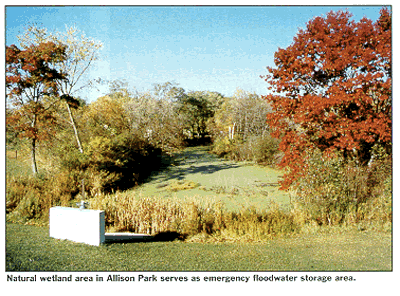
Dike System Protects Richland Center Realizing that local acceptance of the dike hinged on how local residents perceived it would look, Schreiber-Anderson Associates, Madison, WI made a visual assessment study of the impact of the dike and other features of the landscape. Their report included such features as alignment, side slopes to be used, added features to enhance the layout, and recommendations on the use of landscaping to reduce the visual impact. The contractor built a scale model of the dike through Krouskop Park, to show residents how the finished dike would look. The model is still on display in the city library. First, a road system was established to haul fill from borrow areas near the river and upstream from the dike construction sites. The haul road is now a major access point to the city's industrial park. Fortunately, where the haul road crossed the Pine River, there was an opportunity to take advantage of funds from the "timber bridge initiative" sponsored by the US Forest Service. The national initiative promotes the use of timber bridges built with locally grown woods. Wisconsin red pine and red oak were used to make 90-feet-long glued laminated beams. This type of timber bridge is relatively easy to construct and can be put in place rather quickly, using construction equipment usually available to county highway departments. Forest Products Lab monitors the bridge to evaluate its performance. Westbrook & Associates, Spring Green, WI, designed the bridge; Edward Kraemer & Sons, Plain, WI, was the prime contractor; and Sentinel Structures, Peshtigo, WI, was the fabricator. The first phase of the dike work was constructed to protect the Allison Park area at the north end of Richland Center. Completed in 1990, the dike is 4420 feet long with an average height of 12 feet, a base width of 80 feet and a top width of 10 feet. At the point where the dike entered the park proper, it was widened enough for the city to build a city street on top after construction was complete. A natural wetland on the land side of the dike serves as an emergency storage area to handle the 100-year flood in case the river is high and the gravity structures don't function. A 3-1/2 acre pond was excavated in Allison Park to serve as a second storage area and provide extra fill for the dike. The pond also helps to fulfill mitigation requirements as a result of work on the dike in wetlands. The Wisconsin Department of Natural Resources (DNR) stocked the pond with fish. This is a favorite fishing spot for the kids of Richland Center. Larry Allen, SCS, who was Project Engineer and Government Representative for SCS, (now retired), explains a unique system used to handle seepage water from the river during flood flows. "Seepage was a real problem," he said, "because a sand layer about 80 feet deep kept us from building a core trench under the dike. To compensate for this, we built a 3'-wide trench drain at the base of the dike on the land side." To build the drain, the prime contractor, Terra Engineering and Construction, Madison, WI, excavated a trench down to clean sand. After then going 2 feet deeper, the trench was backfilled with fine sand. A layer of coarse gravel was next. This was topped by "turfstones" with rectangular holes. Once this portion of the dike was completed, 352 trees and shrubs were planted in the fall of 1991 by Able Landscaping, Fond du Lac, WI, the landscaping contractor. In operation during high flood flows, seepage water comes under the dike and to the top of this trench drain. It then drains along this stone waterway into outlets where it is stored until the flood water level in the river drops. Since Richland Center had no storm drains, a stormwater diversion was constructed to divert stormwater runoff from 62.5 acres covered by streets and houses in the northern part of the city. A total of 9 drains across two of the streets intercept runoff water and carry it to Pine River in a 72-inch diameter R/C pipe. Joe Daniels Construction Company, Madison, WI, the prime contractor, completed this work in June, 1993. Daniels started construction of a 1,920 foot dike in Krouskop Park in the spring of 1992 and completed the work in June, 1993. Storm runoff on the land side of the dike is carried through a turfstone-lined waterway to several outlets that empty into the river. TNT Enterprises, Suamico, WI, planted 241 trees and shrubs on both the stormwater diversion section and the Krouskop dike section. A walkway created on the top of the dike is heavily used by people of all ages. Starting at the end of the Krouskop Park dike, two more sections totaling about 0.8 mile in length, were built to carry flood water safely past the rest of the city. Most of the side slopes are covered with lawn grasses, with Turfstone covering the rest. Edward Kraemer & Sons, Plain, WI, was the contractor. Construction began in August, 1993 and was completed three years later in September, 1996. Tillman Landscaping-Nursery, Green Bay, WI, planted some 400 trees and shrubs along the dike to create a park-like atmosphere. Many residents enjoy a walkway and bicycle path on top of the dike. A sloping concrete path makes the top of the dike handicap accessible. Five attractive wooden signs positioned at strategic locations, document the specific features of the installation at each spot. The ten home owners and one commercial property owner in the 100-year flood area protected by the project were given an opportunity to have their homes flood- proofed at the expense of the federal government and the city. Some homeowners accepted the offer. The city served as the general contractor to oversee the flood- proofing construction and coordinate activities between the various contractors. A flood warning system was designed by Midstates Associates, Baraboo, WI, as a part of emergency preparedness plan. The plan was prepared by Jim Owen Flood Loss Reduction Associates, Palo Alto, CA. Jim has developed similar plans for communities around the nation. This plan covers such events as a storm greater than the 100-year frequency planned for or any unlikely failure of the dike system. Larry says that many people feel that the flood warning plan paid for itself during the 1992 flood and before all the construction was completed. It helped the local emergency group coordinate the use of resources and carry out evacuation. Many Worked Together Tom McCarthy, a barber and the current Mayor of Richland Center, is understandably pleased with the completed dike system. "It took a lot of time and effort to get this whole project constructed," he says, "but it certainly gives our city a big boost. Now, we can go about our business without fear of costly floods." Darlo Wentz said, "Now that flooding problems in our downtown have been erased, it certainly opens up real estate development possibilities."He cites the relocation of State Highway 14 to the street where railroad tracks have been removed. "Once the highway is on that location," he says, "businesses will undoubtedly develop there in what was once a sort of rundown section of town. Also, early planning is now underway to restore the railroad depot." But Darlo emphasizes that he considers the extraordinary way groups worked together to be the most outstanding feature of the whole watershed project. "It is almost unbelievable to me how so many contributed so much to get this job done. We appreciate everyone's efforts and contributions but especially those of SCS and Larry Allen. We simply can't give enough credit to everyone who helped." Larry modestly accepts any praise, but he quickly adds, "So many people dug in and worked hard for many years to bring this dream to reality. Now, folks here in the city can sleep soundly at night, even during heavy rains. They can rest assured that the dike will do its job." L&W For more information, contact John Ramsden, State Conservation Engineer, NRCS, 6515 Watts Rd., Madison, WI 53719, phone (608)264-5341 ext. 134; or Larry Allen, Project Engineer (Ret), 441 S. Larson St., Richland Center, WI 53581, phone (608)647-3571. |
©2000, 1999, 1998 Land and Water, Inc.