Mitigation Plan Restores 33 Acres of Wetlandsby Steven A. Weller, Environmental Manager, and Mohammed Hassan, Principal-in-Charge, URS/BRW, Chicago, Illinois |
|
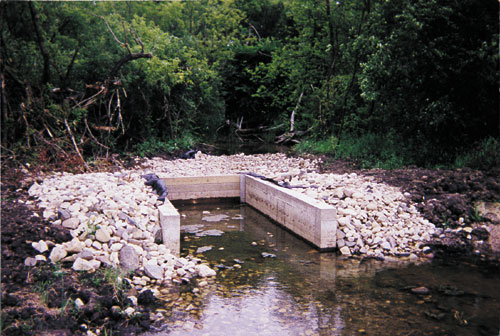
 An articulated concrete mat was placed on both of the berms and the entire 33-acre wetland was covered with aone-inch thick straw mat. Shown is berm in Cell #1 with outlet pipe in Spring 1998. The restoration of a 33-acre wetland site at the corner of Illinois Route 83 and Gilmer Road in Lake County, IL, has improved water control and stabilized hydrological conditions in the area while also creating an aesthetically pleasing environment for users of the heavily traveled commuter highway. The project combines water-control structures designed to sustain water levels during either drought or flood conditions from adjacent Indian Creek along with hydrological design to maintain groundwater conditions. In 1997, at the start of the project, conditions at the site indicated that the deep-water ponds created during previous construction were still present and had not drained. Groundwater was close to the surface, and large amounts of water were entering the site at the culverts under Route 83 and Gilmer Road. In addition, wetland vegetation had developed in the upland area at the south end of the site due to groundwater discharge. Field tile outlets were located and water was observed to be bubbling up at various locations, bringing groundwater within six inches of the surface. Flooding at the site had long been a problem. The Federal Emergency Management Agency (FEMA) maintained a regulatory floodway within the parcel. Surface water entered the site as overflow from Indian Creek, runoff from Route 83 and Gilmer Road, and overland flow from surrounding uplands. Since the site contained adequate groundwater, water-control structures were placed at the north and south ends of the site along with a one-foot-high berm parallel to the creek to increase the control of surface water. A total of three cells with a berm and a water-control structure in between each were designed to effectively manage the hydrology on the site. These features will lessen the impact of one- to two-year flood events. Floods greater than that will overtop the water-control structures and berm. Floodwaters would most likely enter at the north end of the site or back into it from the south. The low berms between the cells should slow velocities of the floodwaters and reduce scour. As added protection, the water-control structures on the berms and the berms themselves allow each cell to hold water and permit evapotranspiration to occur instead of conducting the surface flow back into the stream channel.
Site Design and Construction The intent of the design is to provide a diversity of plant communities, with each targeted at a different wildlife component. Prior to design, a thorough site analysis of environmental conditions was conducted, including soils, hydrology, and vegetation. The resulting design was based on the findings of the vegetation inventory, groundwater, surface water investigations, and soil borings information. Three cells were designed to function as individual wetlands within one large wetland complex. Within each of the three cells is a shallow emergent marsh community as well as wet prairie and wet/mesic prairie communities. The existing riparian corridor was left intact to furnish a diversity of habitat and cover for wildlife. The “no-intrusion zone” composed of reed canary grass was treated with herbicides prior to being graded. Six inches of soil containing the reed canary grass rhizomes was removed and used as fill in the deep ponds on the site, followed by permanent seeding. The adjacent upland buffer had previously been planted with native prairie grasses, forbs, and trees.
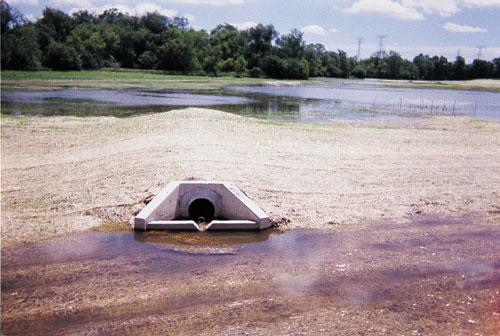
Measures to control erosion included: An erosion protectant surface (articulated concrete mat) was installed, along with an erosion control blanket, on the sideslopes at the triple-barrel box culvert under Route 83. In addition, a small sediment basin was constructed at the base of the slope to reduce water velocities prior to entering the second cell. A heavy-duty fiber mat was installed at the culvert under Oakwood Road and along the slope on the west side of the wetland. This provided an opportunity to maintain the existing slopes and developing seep vegetation while slowing velocities and improving the quality of water entering the site. An articulated concrete mat was placed on both of the berms between the cells as a protection against floodflow velocities. The entire 33-acre wetland area was covered with a one-inch-thick straw mat to ensure topsoil protection against a spring flood as dormant seeding proceeded during the first winter. A determination was made in the field that construction should be performed in a logical sequence that conformed to the topography of the site. This allowed for flexibility in making decisions and provided a safety net in the event of a flood. As a result, the north cell was graded and temporarily seeded while the ponds were being pumped into sediment basins in the other two cells. Once the ponds were de-watered, grading could proceed in the south cell. Any additional water was pumped from the south and north cells into the middle sediment basin and outletted into Indian Creek. Finally, the middle cell was graded and seeded. An Enhancement Area, which consists of 9.5 acres of farmed wetland, was graded and seeded temporarily. The graded material was used for deep fill in the de-watered ponds to remove a seed source of reed canary grass and bring the ponds up to the required elevation prior to placing the topsoil. The large berm at the north end was sorted for unsuitable material to be disposed of and the remaining material was used for fill in the ponds. In this manner, the site was constructed to subgrade and received approval from the Chicago District of the Army Corps of Engineers. Material that was seeded and/or planted to establish wetland vegetation at the site included three acres of shallow emergent marsh plantings and 30 acres of wet prairie that naturally sorts itself into two communities: approximately 19.5 acres of restored wet prairie, 9.5 acres of enhanced wet prairie wetlands; and one acre of wet/mesic prairie transitioning between the wetlands and uplands. The existing upland buffer — about 12.5 acres — contains a native prairie mix of balled and burlapped trees, and has been re-seeded in various locations with the native upland mix. The restored and enhanced wetland acreage satisfies the three mandatory criteria for the federal definition of wetlands: hydrophytic species dominate the wetland areas; wetland hydrology is sufficient to support hydrophytic communities; and 3. soils that exhibit hydric characteristics. Monitoring Plan An extensive and thorough monitoring plan has been developed and is being carried out over a five-year period. It covers vegetation, hydrology, and soils. Vegetation. Quantitative sampling is conducted to measure the presence, dominance, abundance, and total vegetation coverage of plant species in both the created and enhanced wetland areas. Wetland delineations are performed in conjunction with the vegetation sampling. They document the sizes, changes, shapes, and composition of wetland communities as well as the amount of mitigation that qualifies as wetlands at the end of each monitoring period. Cover-type mapping is carried out by aerial photography, and photographs are taken from permanent photo stations, each on an annual basis. Hydrology. Surface water and groundwater elevations are recorded quarterly to establish post-construction hydrologic patterns. The site contains three shallow monitoring wells for which there is a full year of weekly data. Soils. Observable soil properties may not change within the duration of the monitoring program. However, one soil sample will be taken annually in each wetland community. The recently completed project has restored a natural setting, with wildlife habitat and scenic improvement, at the traffic-signal intersection, providing users of the highway with views of the wet prairie, wetland marsh, and tree-lined corridor along Indian Creek. Environmentally, the wildlife habitat has been increased, with more than a dozen species of water birds and shore birds having been inventoried on the site, including two Illinois endangered species. The vegetation monitoring indicates all wetland species that were planted are present and native coverage is nearly 90 percent of the site, following the first two growing seasons. Future plans call for a hike/bike trail along the upland adjacent to Route 83 overlooking the wetland restoration site. L&W For more information, contact Steven Weller or Mohammed Hassan, URS/BRW, 547 W. Jackson Blvd., Ste 1500, Chicago, IL 60661, (312)461-0267, fax (312)461-0373. |
©2000, 1999, 1998 Land and Water, Inc.