Building a Major Highway in Mountianous East Tennessee: Enviromental Impactsby Pam Boaze and Barbara Wiggins |
||
| If you've ever driven a winding mountain road, you know what it is like getting stuck behind a tractor trailer going up the hill. Or worse, coming down the mountain in front of a tractor trailer. This was the typical experience on the old US 23 in Tennessee from the Town of Erwin to Sams Gap at the top of the mountains, dividing Tennessee and North Carolina.
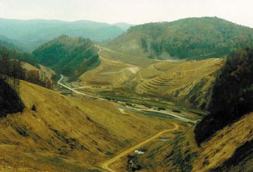
No one can deny that the new Interstate road is a vast improvement travelwise. But what was the environmental cost of this new road? It certainly looked like the Tennessee Department of Transportation (TDOT) tore up the world while they were building the road. And there were times when the streams ran muddy. Was there any permanent damage?
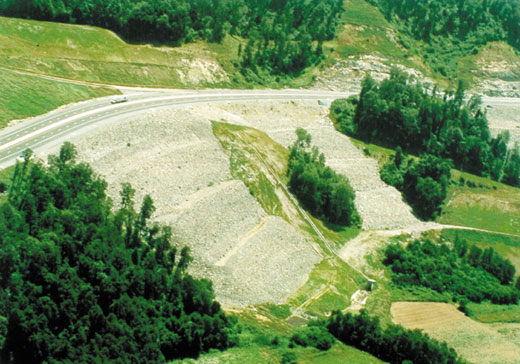
The construction of US 23 (Future I-26) was one of the largest and most environmentally sensitive projects ever undertaken by TDOT. The 15.3 mile project began in 1990 on the first section just outside of Erwin in the rolling hills and valleys of East Tennessee. The final sections along the steep grades of the Appalachian slopes were completed in 1995, with the road open to traffic in July 1995. TDOT built the new highway to replace the steep and narrow US 23 as part of the Appalachian Development Highway System guidelines from the 1960's. This road would also provide an alternate road across the Appalachian mountains in case I-40 between Asheville, NC and Knoxville, TN had to be closed for any reason. Early in the planning and review of the project, environmental concerns were identified, including: erosion; sedimentation; pyritic rock; wildlife crossing; water quality; and aquatic community health. Most of the emphasis was placed on impacts to the aquatic environment. Pyritic rock, often called "hot rock" or "acid rock", was considered the most critical environmental problem. When exposed to air and water, this rock chemically reacts to form acid. Leaching from the exposed areas and from the waste piles can cause the pH to drop to a lethal level in the streams. TDOT did borings along the proposed route to determine the extent and potency of the pyritic rock. The waste with a low potential for acid was neutralized with lime, while the highly acidic waste was encapsulated.
Geomembrane encapsulation was a new technique, used in the field by TDOT for the first time on this project, and naturally, there were some problems. Imagine trying to wrap a package outdoors on a windy day without tearing the wrapping paper. Then, imagine a package that is 75,000 cubic yards in size and it will take one year to wrap the box. Once wrapped and sealed though, this membrane keeps everything inside, inside. Monitoring throughout the project showed that no acid leachate was found anywhere on the constructed area. This part of the environmental control was definitely considered a success. Erosion and sedimentation in the streams were not as easily contained. Despite erosion control efforts, sediment was being lost during storm events. Working together with the Tennessee Department of Conservation and citizen groups, TDOT tried many methods available to control erosion. TDOT hired a consultant knowledgeable in erosion control to make recommendations, developed a plan to restore the streams, monitored the aquatic communities, and utilized bioengineering techniques to stabilize the slopes and streambanks. Some things worked, some things didn’t.
According to Ray Brisson, TDOT Planning Department, "There was recognition early in the project that the planning process was not adequate to the extent necessary". Previous TDOT projects had not encountered the steep terrain of this project and planning did not take this completely under consideration.
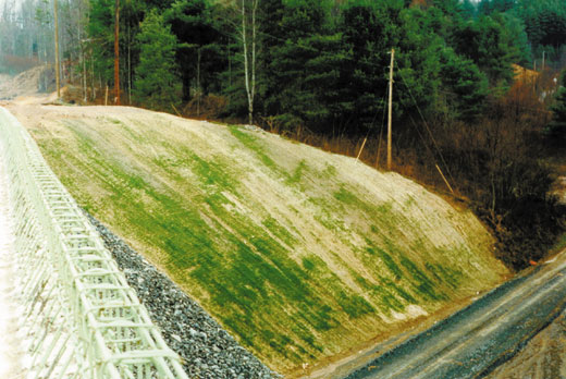
W.K. Dickson, Inc., the erosion control contractor, noted that the best way to control erosion and sedimentation was to minimize the time that raw earth is exposed. They recommended clearing be coordinated with construction on an as-needed basis. It was important to apply temporary seeding whenever bare areas were not being worked. Permanent vegetation included a variety of plants to provide both short term coverage and long term stabilization. Maintenance of already installed erosion structures was the first priority after a storm. Fiber mats were used in addition to hydroseeding to stabilize steep areas. Diversion pipes and cloth liner under drains were installed to cut down on sediment loss.
Bioengineering techniques to stabilize slopes and streambanks, used by TDOT for the first time on this project, consisted of numerous plantings, both stakes and rooted plants. This is a very labor intensive, costly procedure as it is all hand placement of shrubs and seedlings. Unfortunately, the bioengineering efforts were plagued with setbacks. Contract laborers planted rhododendron seedlings without removing them from the pots. Many of the plants were stolen, and in one instance, the adjacent landowner mowed all the vegetation right to the edge of the stream because he did not like the 'weedy' look. Ditches were a problem: they would be lined with rock and then the next storm would blow out the ditch. One blown-out ditch was repaired with car size boulders instead of the 12-inch riprap originally planned (Harold Martin, TDOT Regional Engineer). The planning and design process had failed to take into account the velocity of runoff in the mountains. This was mostly a factor of the ditches being designed to handle the "normal" storm. Unfortunately during the construction, there were several ten-year storm events, as well as the remnants of Hurricane Opal. Mountainous regions, especially the Southern Appalachians along the Tennessee-North Carolina border, are notorious for the high amounts of precipitation they receive.  Some flooding was also caused by the stormwater runoff. Forested slopes and leaf litter which retain water and slow down the runoff from storms were removed en masse. Without obstacles to break up the flow and root channels to provide conduits for water filtering down through the soil, increased runoff inevitably results. Although this was expected in a general way by TDOT, flooding of downstream areas came as a surprise. Quick response by the Regional Engineer alleviated the problem. Variable outlet structures, retention ponds, and velocity reduction devices were installed to hold back some of the water temporarily. Special structures were used in large fill areas, such as a concrete flume to carry the runoff to a retention pond where the release was controlled. Because of the concerns about impacts from the sedimentation and habitat changes to the creeks, aquatic community monitoring was performed. This monitoring included surveys of the fish population, macroinvertebrates, and deposited sediments in the creeks affected by the road construction. These studies began in 1990, prior to the initiation of construction, and continued until the last few samplings in 1999. Impacts to the aquatic communities were found only in the locations experiencing major sedimentation. Within a year of the increased erosion control efforts (1993-1994), no impacts to the fish communities were found in the major tributaries. By the end of the construction project, surveys had found over 400 different species of macroinvertebrates, as well as 33 species of fish in South Indian Creek and its tributaries. Deposited sediment flushed out during the winter and spring high flows. No long-term interference with reproduction or unusual mortality to the aquatic community was found due to sedimentation. A healthy mountain stream usually contains three types of habitat: riffles which are shallow rocky areas with turbulent water; runs which are deeper areas where the water surface is smooth; and pools. The riffle areas provide the most habitat for macroinvertebrates as well as small fish. Out of the whole South Indian Creek watershed, only Sams Creek showed an impact from the additional runoff. This was the only creek in the watershed showing macroinvertebrate community impacts after the construction was completed and the hillsides stabilized with vegetation. Sams Creek starts as a series of small head water tributaries in the Sams Gap area flowing together to form a small creek about 3 to 4 feet wide. Over the course of the road construction, a gradual change was noted in the habitat as Sams Creek received more water from runoff and diversion. The riffle habitat was lost, until the entire creek was runs interrupted by plunge pools. As vegetation becomes re-established on the slopes, the creek will probably regain some riffle habitat. The building of this future interstate in Unicoi County initiated many new programs and environmental awareness throughout the state. Cooperation between the Department of Transportation and the state resource agencies to solve environmental problems was strengthened. Starting in 1993, meetings with state and local environmental groups and others were held on a regular basis to discuss the construction progress and efforts to control erosion. Weekly inspections of the project were conducted jointly by Tennessee Department of Environmental Conservation and TDOT personnel. The creation of TDOT regional environmental coordinators’ positions, begun mid-way through the US 23 project, provided a constant presence to protect the natural resources, while allowing road construction to progress in a timely manner. There were also lessons to be heeded for future projects. New techniques and materials, such as geomembrane encapsulation and bioengineering, were tested and problems were worked out. The successful containment of the hot rock is one example of new techniques and good environmental planning. In hindsight, the construction of the new four lane road did not impact the aquatic environment permanently. There were some temporary problems with sedimentation, but it did not destroy or even impair the aquatic community. Quite rightfully, various citizens and agencies called attention to temporary environmental concerns during the construction. TDOT and construction personnel were responsive and ingenious in solving the problems as they arose. Now, five years after completion, everyone involved with the construction of this interstate can say, “We did a good job.” There is a safer, better roadway. L&W For more information, contact Charles Bush, Tennessee Department of Transportation, Suite 900, James K. Polk Bldg., 505 Deaderick Street, Nashville, TN., 37243-0334, (615)741-3653, fax (615)741-1098, e-mail cbush@mail.state.tn.us, or Pam Boaze, Fish & Wildlife Associates, Inc., PO Box 241, Whittier, NC. 28789, (828)497-6505, fax (828)497-6213, e-mail fwa@dnet.net. |
©2000, 1999, 1998 Land and Water, Inc.