Erosion Control in Florida's Little Wekiva Riverby Mary Brabham and Jeff Cole |
|||
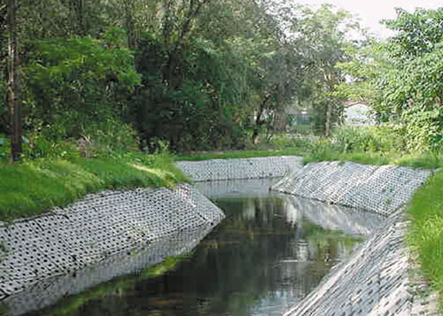
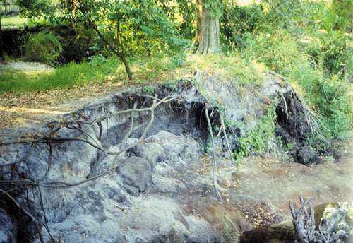 Typical erosion along the Little Wekiva River in Central Florida.
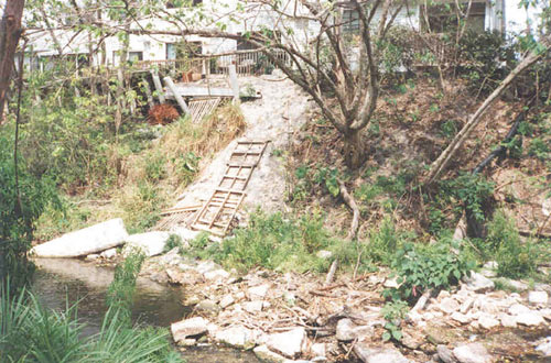
With each heavy rain that falls in downtown Orlando, Florida, stormwater rushes through ditches and into a small river surrounded by densely populated communities. So much water flows from a 42-square-mile urban area into the Little Wekiva River that a one-inch rainfall can raise river water levels by four feet or more. During Florida’s summer rainy season, the heavy flows into and through the 15-mile-long river have led to erosion of the river’s side banks and channel bottom. The buildup of sediments in some areas has caused flooding in the surrounding residential communities, and has deteriorated water quality in the Little Wekiva River and the downstream federally-recognized Wekiva River. As the population of Orlando and its surrounding communities in Orange and Seminole counties has more than doubled in the past 30 years to 1.2 million, the volume and rate of stormwater flowing into the Little Wekiva River has also grown. Much of the development within the Little Wekiva’s basin occurred before stormwater regulations were put in place, leaving only minimal stormwater storage and treatment upstream of the Little Wekiva River. Concerns for public safety caused by the flooding and erosion, along with adverse environmental and water quality impacts from the movement and settling of sediments, led to the formation of partnerships among government agencies and the public.
Partnerships are Formed Representatives on the working group include: the Florida Department of Environmental Protection; Florida Department of Transportation; St. John’s River Water Management District; Orange and Seminole counties; the city of Altamonte Springs; Florida Audubon Society; and area residents and the grassroots Friends of the Wekiva River. With strong support from the area’s elected state officials, the Florida Legislature has given $6.15 million that the working group has combined with more than $6 million from local governments and the water management district. The funding has enabled the group to develop a basinwide master plan to address erosion and sedimentation problems, while also allowing for the construction of projects. The projects in the master plan provide benefits to both the spring-fed Little Wekiva and Wekiva rivers. The Little Wekiva projects address public safety, flood protection and structural stability, while the Wekiva River will receive secondary benefits through improved water quality and less sediment deposition. The 42-mile-long Wekiva River is one of Florida’s most recognized and valued natural resources, having been named a federal Wild and Scenic River and a State of Florida Outstanding Water and Aquatic Preserve. Government agencies have worked together to bring more than 68,000 acres of land around the Little Wekiva and Wekiva rivers into public ownership and have enacted tighter development regulations within the basin. The Wekiva River Protection Act, enacted in 1988 by the Florida Legislature, laid the ground work for providing long-term protection.
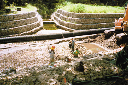
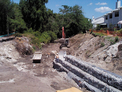
Projects Take Shape Nearly 1,700 linear feet of structural protection has been intermittently installed at high erosion sites along the 15-mile-long Little Wekiva River. The type of river bed and bank erosion control material used at a site has been determined by the slope of the channel bank and land available. Most of the highest priority locations required gabions, due to the near-vertical side slopes and severe erosion damage that had occurred. Also included in the high priority measures was the need to install a series of grade control structures - dams and weirs. Because much of the erosion is a stripping away of the channel bottom, the dams and weirs help restore the grade of the river and prevent further erosion of the bottom. The structures are constructed of gabions that are stretched across the channel. Additional bed and bank protection has been constructed immediately upstream and downstream of each grade control structure to protect the area from the turbulence that the small dams can cause. Lessons Learned During Construction Construction in a flowing stream can be tedious, and work was undertaken to ensure that sediments did not flow downstream. Rain storms frequently occur with little warning in Florida, requiring that contractors be able to deal with sudden large flows of water. Groundwater seepage into the work area can be a problem and is removed with pumps. Several different construction techniques have been implemented in the Little Wekiva River with varying results. Since each site has its own unique characteristics, each project has been developed around specific site conditions. Because dry sites allow for the best construction access, stream flow has been temporarily rerouted, where possible, for the construction process. One of the most successful construction methods has involved using pumps and pipes to move the entire river flow around sections under construction. For this technique, water discharged back into the stream has been controlled to prevent further erosion. Other construction methods have involved channeling the river flow away from the construction using sheet pile, and combining pipe installation for continuous gravity flow with a pump for excess flow. For all of the methods of stream flow management, gravel dams built downstream of the project sites have helped remove sediments and allow for Florida water quality standards to be met. A series of dams has been typically required, with the number dependent on soil types, flow and the amount of disturbed area. Silt fences, geotechnical fabrics, polymer additions, turbidity barriers and temporary staked sod have also been necessary to limit the movement of sediments downstream during construction.
Continuing the Efforts In the short time that the Little Wekiva River Technical Working Group has been in existence, it has already made significant accomplishments. In just six years, it has completed the basinwide management plan for erosion control, and constructed the three highest priority projects. The group recognized the urgency of work in the Little Wekiva River after one summer of heavy rainfall followed nearly 30 years of drought conditions in central Florida. The momentum has been maintained, with local and state governments and advocacy groups working together, to continue to accomplish more projects in the basin. While work on the immediate needs caused by the erosion are being addressed, efforts are also under way to plan solutions to address the excess stormwater being channeled into the river.
Construction is planned to begin on two projects in early 2001, with design work to begin on five more projects later in the year. The Florida Legislature’s support is allowing the working group to move forward with the design and construction of even more projects for the near future, stepping closer to improving the entire Wekiva River watershed. L&W For more information about the Little Wekiva River, visit the water management districts Internet site http://sjr.state.fl.us or call (407) 897-4300. Mary Brabham, an engineer, is the Little Wekiva River project manager for the St. Johns River Water Management District. Jeff Cole is a regional communications coordinator for the St. Johns River Water Management District. |
©2001, 2000, 1999, 1998 Land and Water, Inc.