On April 14, 2000, a celebration was held in Cheyenne, Oklahoma, to dedicate the first flood control dam in the nation to be rehabilitated to extend its life for another 100 years.
Background
The five million-acre Washita River Basin is located in southwestern Oklahoma. In the early 1900s, this river basin experienced many devastating floods that caused millions of dollars of destruction of agricultural crops, roads and bridges, homes and businesses, as well as causing major disruption to peoples lives on an almost annual basis. One of the most devastating floods occurred near Hammon, Oklahoma, on April 3-4, 1934. Although the area around Hammon received less than two inches of rain, records of as much as 20 inches were reported in upstream areas. The Weather Bureau at Cheyenne, near the mouth of Sergeant Major Creek Watershed, unofficially reported 14 inches in 6 hours. The floodwaters concentrated so rapidly that many people were washed away with their homes. Seventeen people lost their lives.
Following this flood, local community leaders raised national awareness of the need for upstream flood control and watershed protection. Congress passed the Flood Control Act of 1944 (Public Law 78-534) which authorized 11 watershed projects across the nation. The Washita River Basin was one of these eleven projects. On July 8, 1948, the first upstream flood control dam in the nation (Cloud Creek, Site 1) was dedicated near Cordell, Oklahoma. Since that time, 1,140 small upstream flood control dams have been constructed in the Basin. These dams control runoff from 60 percent of the entire Washita River Basin drainage area. Some dams also include municipal water supply, recreation facilities, and fish and wildlife habitat improvement.
The small flood control dams typically consist of an earthen embankment with heights ranging from 20 to 60 feet. The dams have relatively small drainage areas of 1 to 10 square miles, located on intermittent streams in the upper reaches of watershed tributaries. The inlet of the principal spillway, generally reinforced concrete pipe 12 to 48 inches in diameter, is placed at an elevation that provides storage in the reservoir for the anticipated sediment to be accumulated during the design life of the structure. An emergency spillway (usually a vegetated channel) safely conveys runoff from storms that exceed the design storm. The detention storage available between the principal and auxiliary spillways provides temporary storage of runoff until it can be slowly released through the principal spillway pipe. With several dams in a watershed, this temporary retention of runoff controls flooding to downstream floodplain areas.
| The purpose of the project was to show how reinvestment in older watershed projects can provide future benefits. |
The following provides the basis for one example of success: the USGS Gauging Station near Cheyenne, OK measures the actual flow in the Washita River. Based upon these records from 1938 to 1961, the 100-year frequency flood at this location was 105,000 cubic feet per second. In the 1950s and 1960s, 84 dams were built upstream from this gauging station as a part of the PL-534 Washita River Basin Project. These dams control runoff from 65% of the 794 square miles of drainage area. A review of the actual flow data in the river from the USGS gauging station for the period 1961 to 1994 shows that the 100-year flood frequency is now only 14,0303 cfs. This is a 90 percent reduction in peak flood flows in the river. The last two generations of residents in Cheyenne have not experienced the economic impact and devastation on peoples lives that a flood produces. This success has given many residents a false sense of security since most do not realize the impact that time has taken on the aging infrastructure upstream from them.
Authority
On July 3, 1998, NRCS Chief Pearlie Reed announced that $750,000 in NRCS funds would be provided to Oklahoma for a pilot rehabilitation project for the small watershed program. Oklahoma has 2,094 project flood control dams. Several are at or near the end of their design life. The purpose of the project was to show how reinvestment in older watershed projects can provide future benefits. Authority was provided in the FY-1998 Appropriations Bill.
Objectives
The objectives of this pilot rehabilitation project included:
- Facilitate and provide technical assistance to a locally-led planning effort to address all resource needs within a watershed.
- Document a streamlined process to develop a rehabilitation plan.
- Rehabilitate high priority dams.
Project Selection
A competitive process was implemented to assure a viable project with local support was selected. Sixteen of 126 Oklahoma watershed projects met the selection criteria established. Nine proposals were received from project sponsors. Selection was made by representatives from NRCS, Oklahoma Conservation Commission, and Oklahoma Association of Conservation Districts.
Sergeant Major Creek Watershed
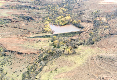
The Sergeant Major Creek Watershed consists of 19,684 acres and is part of the Washita River watershed (one of the original 11 projects flood control projects authorized by PL-534). Six small flood control dams were constructed from 1948 to 1963. The Upper Washita Conservation District serves as local sponsors for this project. One dam (Site 2) had a hazard classification change due to downstream development, structural problems with the principal spillway, and excessive foundation seepage. The sediment pool of another dam (Site 4) is used as the sole source water supply for the town of Cheyenne (population 1,000). Some of the older dams are rapidly filling with sediment; with Site 1 being essentially full.
Sergeant Major Dam No. 2 reconstructed in April 2000.
Locally-Led Planning Effort
A 15-member local coordinating group was formed to identify local community and resource needs to be addressed within Sergeant Major Creek Watershed. This group was comprised of landowners, representatives from the town of Cheyenne, and other interested citizens.
Six objectives developed by this local work group included:
- Rehabilitation of flood control Sites 1 & 2.
- Protection of the town’s drinking water supply.
- Improvement of rangeland conditions and wildlife habitat.
- Rehabilitation of aging conservation practices.
- Education of oil and gas company representatives in erosion control around well sites.
- Solving storm runoff problems within the town.
The pilot project proceeded with the planning and construction of the rehabilitation of the two flood control structures, while the local coordinating group took actions to address the other objectives.
Planning Efforts
The Oklahoma NRCS Watershed Planning staff facilitated the planning of the rehabilitation of Sites 1 and 2, that were originally constructed in 1948 and 1949, respectively. This provided for the implementation of the rehabilitation component of the objectives identified by the locally-led effort.
A supplement to the original work plan was prepared and an environmental assessment was conducted to document any significant impacts that rehabilitation of these flood control dams might cause. The environmental assessment of the planned actions showed no significant adverse impacts to the land, water, air, or wildlife resources within the watershed. In fact, enhancement of wildlife habitat, stream fisheries, water quality, and wetlands were identified as benefits of this project. The planning effort included:
- Conducting extensive resource inventories.
- Preparing a supplement to the original work plan.
- Preparing an environmental assessment.
- Issuing a Finding of No Significant Impact.
- Preparing and signing a new Operations and Maintenance Agreement.
- Signing new landrights documents (landrights were donated by the landowners).
- Preparing and signing a new Operations and Maintenance Agreement.
- Submitting applications for 404 and state dam safety permits.
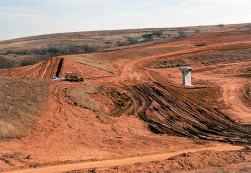
Dam No. 1: Originally constructed in 1948. Second dam to be rehabilitated. Reconstruction began March 2000. (Photo b NRCS)
Description of Work
The actual work performed in the rehabilitation of Sites 1 & 2 included:
- Plugging the existing principal spillways for abandonment.
- Installing new principal spillways and appurtenances.
- Installing foundation drains.
- Flattening the backslopes.
- Raising the emergency spillway and top of dam to meet hydraulic capacity requirements.
- Providing fire protection storage on Site 2, with added costs covered by the state of Oklahoma.
- Providing storage for 100-year sediment accumulation.
- Meeting all NRCS and state dam safety concerns.
Financial Summary
State Conservationist Ron Clark made the determination that the $750,000 provided would be used solely as financial assistance funding, with all technical assistance funds being provided by Oklahoma. Detailed records of technical assistance provided were kept. A total of nine staff years of 25 staff members were used during the two-year period of planning, design, and construction of the project (planning - 2.4 staff years; design - 3.3 staff years; construction - 3.3 staff years).
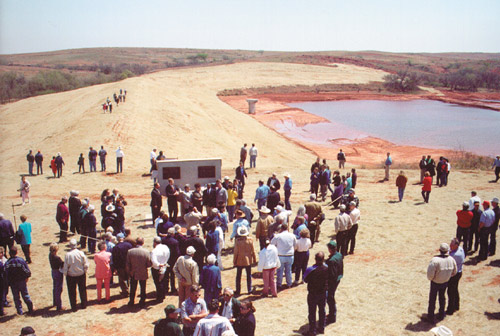
Rededication Ceremony
On April 4, 2000, a celebration was held in Cheyenne, Oklahoma, to dedicate the first small flood control dam in the nation to be rehabilitated to extend its life for another 100 years. U.S. Congressman Frank Lucas, NRCS Chief Pearlie Reed, and FEMA Associate Director Mike Armstrong were keynote speakers at the celebration. The event consisted of a public ceremony at the Cheyenne High School Auditorium, a free BBQ lunch for all attendees (800 people served), and a rededication ceremony at Site 2. The local Cheyenne community hosted this celebration that involved considerable community input.
Lessons Learned for Future Efforts
Since there was no existing experience base for rehabilitation efforts, unanticipated opportunities were encountered throughout the duration of this project. These are presented as considerations to aid future rehabilitation efforts by NRCS.
Public awareness of the benefits provided by these structures need to be enhanced. Older generations that have experienced first-hand the devastation of floods are well aware of the need for maintaining flood control structures. Younger generations do not understand the need or importance of the structures.
√ Planning and design of rehabilitation requires more experienced staff. Original design documentation may be sketchy or unavailable. A “forensic” approach is needed to achieve a quality product.
√ Planning and design for rehabilitation require more time than new project designs.
√ Extensive site-specific data is needed.
√ Landrights could be a major obstacle. Developments, utilities, and other items may limit areas available for construction.
√ Every rehabilitation plan is unique. Each project must consider site-specific conditions and resource and social needs of the community. L&W
For more information, contact Larry Caldwell, National Policy Coordinator, Aging Watershed Infrastructure, USDA NRCS, 100 USDA Suite 206, Stillwater, OK 74074-2655, (405)742-1254, fax (405)742-1287, Larry.Caldwell@ok.usda.gov.
|