Houston Makes a Big Splash with Ship Channel Expansion Projectby Laura Fiffick |
|||
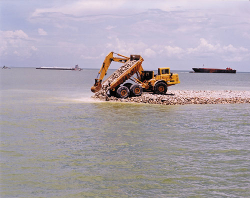
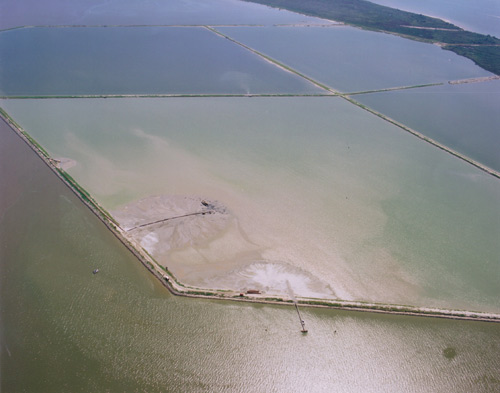 Pipelines transport dredge into a cell at Atkinson Island. Once the cell is filled, it takes approximately two years for the material to settle to inter-tidal level. Suppose you had more than 200 million cubic yards of silt and clay at your disposal. What would you do with it? The Port of Houston Authority (Port) and U.S. Army Corps of Engineers (Corps) were posed that question thirteen years ago when they began an expansion of the Houston Ship Channel and the Galveston Harbor and Channels under the Houston-Galveston Navigation Channels (HGNC) project. The Port and the Corps have since answered the question with environmentally friendly ways to utilize dredge material in one of the most unique navigation projects ever undertaken in the nation. The Houston Ship Channel has long attracted diverse businesses to transport goods and fuel the regional economy. Since 1837, when the steamship Laura traveled from Galveston Bay up Buffalo Bayou to what is now Houston, the waterway has provided a vital commercial link from Houston to the rest of the world. With the development of the Port of Houston in 1914, deep-water vessels began serving as local economic catalysts, providing jobs and much-needed revenue to communities in the Houston-Galveston area. Almost a century later, the Port ranks number one in the United States in foreign waterborne commerce. In 2001 alone, nearly 7,000 ships carrying 194 million tons of cargo used the waterway, which generates $10.9 billion in revenue annually. Port business operations have created more than 300,000 jobs in Texas and 700,000 jobs nationally. With so much riding on the continued ability of the Port to sustain its regional and national economic benefits, the Port and the Corps embarked on a more than $500 million ship channel expansion project. The expansion called for the Houston Ship Channel to be deepened by five feet and widened by 130 feet for a total depth of 45 feet and bottom width of 530 feet allowing larger vessels to safely and efficiently navigate the channel. After gaining Harris County voter approval of a $130 million bond issue and the necessary local funding, construction started in October of 1997. While expanding the channel by dredging silt and clay was a seemingly simple task, discarding the dredged material was not. When creating a plan to dispose the dredged material, open bay disposal, or placing the unconfined dredge material in the middle of Galveston Bay, was ruled out as an option for a number of environmental considerations. With this in mind, the Port and Corps worked through two groups to create a new proposal that now serves as a global model on how to conduct ship channel maintenance in a way that benefits the environment and fisheries. The Port and the Corps created a subcommittee of the Interagency Coordination Team (ICT), a problem-solving team charged with overseeing the planning, engineering and post-project monitoring of environmental issues concerning the channel expansion. Operating under the ICT, the Benficial Uses Group (BUG) is an unprecedented coalition of eight governmental agencies given the specific task of identifying environmentally and economically responsible ways to utilize the material dredged from the HGNC expansion. "As the material is dug out, it's being placed in specifically located and contained areas to create environmentally beneficial islands and marshes," said Andy Sipocz, a Texas Parks and Wildlife biologist in Dickinson. "Because we're shaping the material so it breaks the surface of the water, it displaces less of the bottom. Also, we're creating more marsh along shorelines near natural marshes. All the material will be confined behind levees of stone or earth, including material from ongoing maintenance dredging of the Houston ship channel, which will help keep bay waters much clearer than they would have been otherwise."
While the initial goal of the expansion was to spur economic growth by allowing more efficient shipments of cargo through the navigation channels, the results are leading to impressive environmental improvements for the Bay. "The Port's continuing goal is to contribute to and enhance Houston and the surrounding areas, and the HGNC expansion project with its accompanying environmental plan accomplishes this mission," said Jim Edmonds, chairman of the Port Commissioners. "Projects such as this one, which not only profit businesses, but also aid the wetlands and wildlife habitat, show that business and the environment are not mutually exclusive. In this situation, helping the environment is also great for the continuance of business." Despite the BUG's positive environmental objectives, not all property owners and conservationists in the Houston-Galveston region were initially behind the expansion project. Many area residents stressed concern about the potential of property devaluation and environmental hazards. In order to overcome these fears, the BUG scheduled informal meetings, called "kitchen table talks," to inform the public and gain feedback from the local community on a variety of possible uses for the dredged material. After much investigation and study, the BUG produced a 50-year plan, dubbed "the BUG Plan," to take advantage of the dredged materials. The BUG Plan included creating 4,250 acres of inter-tidal wetland habitat; a six-acre bird nesting island; an offshore underwater berm to produce habitat to attract fish; access channels and anchorages for recreational boaters; 118 acres of oyster reefs to mitigate for oysters impacted along the channel side slopes and under the mid bay placement area; and partial restoration of two previously existing islands which had eroded over the years. The BUG Plan provides a placement area for material dredged from the initial expansion construction as well as the ensuing 50 years of channel maintenance. In 1992, the plan was adopted by the ICT and received unanimous support from all federal and state resource agencies. "Through extensive teamwork and community involvement, the Port, Corps and the BUG developed a plan that outlined environmental uses for the dredge material and addressed the concerns and desires of most everyone who offered input," said Col. Leonard Waterworth, Commander of the Galveston District Corps of Engineers. "It has been rewarding to take part in a project where so many different groups successfully come together to improve Galveston Bay and the surrounding areas both financially and environmentally. The results have been phenomenal."
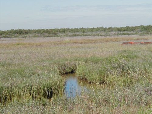
After finalizing the plan, the BUG began creating a living laboratory that would serve as the model for all future developments. Without previous examples on which to base the unprecedented construction, the Port and the Corps, together with recommendations from the BUG, created the 220-acre Demonstration Marsh. This marsh allowed BUG members to test and study elements of their plan on a small scale before implementing the larger scale project. The marsh was constructed in several stages. First, the Corps, in charge of construction for the project, shaped and placed containment levees for the softer dredged material. Weir boxes were then added to allow for drainage and circulation. Once this was completed, shoreline protection was placed along the levees to prevent erosion. Under direction of the Port, pipelines then pumped the soft dredge material into the interior of the cell. Engineers made detailed calculations on how much material should be placed in the cell so that after it settled, the inter-tidal level would be between 0.6 and 1.4 feet above mean low tide. The settling and water drainage process took approximately two years, during which time the bulk of the dredged material began to dry and marsh grass was planted. As the material settled, the BUG monitored the site and subsequently installed creeks and ponds to bring tidal circulation throughout. "The Demonstration Marsh is a living laboratory for us to study," says Dick Gorini, chairman of BUG and former environmental affairs manager for the Port of Houston Authority. "By monitoring and documenting the growth and changes within the marsh, we have learned a number of valuable lessons that have helped us as we work to build new marshes in the area and improve the overall quality of life in Galveston Bay." Among other things, since the Demonstration Marsh was completed in 1995, the marsh has been pivotal in determining how water circulates through channels in and around man-made marshes, providing information on the channel development essential to plants and wildlife in the marsh. Information about vegetation has been another highly anticipated area of study at the marsh. The work has taught the group effective ways of spacing plants and seedlings for healthy growth.
In addition to providing scientific data, the marsh helped engineers and biologists learn a number of lessons that they could apply to the larger project:
Eight years after its completion, the marsh is thriving. While much has already been learned from it, it will continue to serve as a living laboratory for scientists and engineers until the project is complete in 2050. "The Demonstration Marsh is working both as a marsh and particularly as a laboratory," notes Gorini. "Vegetation is thick and lush, wildlife is using the marsh-water (or "edge") and a variety of birds - including some endangered species - are making their home there." Armed with the knowledge gained through the marsh, the BUG, Port and Corps focused on creating additional environmental features throughout Galveston Bay, including Evia Island, a colonial water bird nesting island. In roughly six weeks, six acres of dredged material were placed to create the island. In March 2002, the Audubon Society oversaw the planting of a variety of vegetation on the island to attract wildlife and prevent erosion. Today, Evia Island has become a popular native bird-nesting sanctuary with tremendous ecological significance. The habitat is one of few remaining protected nesting area in the vicinity for many rare shore birds. "Every nesting season, the U.S. Fish and Wildlife Service, the Houston Audubon Society and other groups conduct the Texas Colonial Waterbird Survey to determine the bird population around the Bay," explains Phil Glass, BUG member and biologist with the U.S. Fish and Wildlife Service. "In the late 1990s, we noticed a decrease in nesting populations of certain species of colonial waterbirds in Galveston Bay. We attributed this to increased human disturbance and loss of some important islands to erosion."
Almost immediately after completion, Evia Island, created solely as a bird habitat, showed impressive numbers. In 2001, more than 3,000 birds were present on Evia Island. The birds nesting on the island included an estimated 750 royal terns, 12 gull-billed terns, 950 sandwich terns, 10 forester terns and 450 black skimmers. The federally listed endangered brown pelican is also now using the island. The BUG hopes to see as many as 2,500 nesting pairs of 6 to 10 species per year in the near future. "We are very pleased at how well the birds are adapting to their new home," says Glass. "By restoring this lost habitat, the Port, Corps and the BUG are improving Galveston Bay and bringing back more wildlife to the area." Aside from benefiting native water birds, the man-made inter-tidal marshes have had a profound positive effect on the Bay's ecosystem. The marshes produce a variety of marine species, including red drum, flounder and shrimp, while helping to remove pollutants in the Bay and coastal waters. This is especially good for the regional fishing industry, which generates about $200 million in annual revenue. Galveston Bay currently accounts for roughly 30 percent of oysters harvested in the United States and 70 percent of the Texas supply. Experts in this field expect oysters to become even more commercially productive as the project reconstructs 118 acres of eroded oyster substrate. Already a number of local residents have noticed improved fishing near BUG's habitat sites. The project has also had positive effects on recreation in Galveston Bay. Due to overwhelming community interest determined through the kitchen table talks and continued in subsequent community meetings, the Port, Corps and BUG included the partial restoration of Redfish Island, a popular boater anchorage that eroded below the water's surface more than a decade prior, in the plan. The construction of Redfish Island was included in the BUG Plan and provides additional bird habitat, substrate for oysters, and a protected anchorage for recreational boaters. Limestone rock and shell hash were used to construct the island since it was determined that sediments from the dredged material may impact an existing oyster reef in the area. The decision to go forward with construction was well received in the surrounding communities.
"We are very appreciative to the Port, Corp and BUG for going above and beyond the initial bay plan to further enhance the environment and safety in Galveston Bay," said Captain Gene Schwantes, owner of Windward Sea Venture Enterprises and founding member of BaySmart, an organization which provides Galveston Bay-related educational experiences to the general public. "Recreational boaters on the east side of the channel who are not comfortable converging into commercial traffic in Galveston Bay can now anchor at Redfish Island, avoid crossing the ship channel, and enjoy the bay more than they have for the past decade." On June 6, 2002, Port and the Corps started the substantial task of reconstructing the island. Construction lasted 102 days, required approximately 50 different pieces of aquatic machinery, and cost $7.2 million. The restoration involved carting 140 barge loads of limestone to the middle of the bay, placing more than 206,000 tons of limestone below the water to create the island, and then covering the north end and interior side slope of the island with 3,000 tons of shell. During formation, the six-acre, 7-foot-high island was divided into three sections: a bird habitat at the north end, a breakwater at the south end, and a main body located between the two ends. The bird sanctuary and breakwater were constructed with barges and large cranes. The center section was made later by building a pad above the water with a crane, then expanding this pad by hauling limestone from both directions with dump trucks until the center section was complete. The much anticipated milestone re-opening of Redfish Island, called "Life Returns to Redfish: A Promise Kept," was celebrated on March 29, 2003, with a chartered boat ride around the Bay, educational project displays, and a special appearance by U.S. Representative Nick Lampson of Texas' Ninth Congressional District. Attendees expressed gratitude to the Port, Corps and BUG for delivering on the promise to make a better bay. The successful event gave recognition for a job well done, but an ample amount of work on the project remains. While the HGNC expansion project is scheduled to continue only through mid-2004, the present effort to revitalize the Bay will continue through 2050. Throughout the process, the Port, Corps and BUG have worked together to overcome all challenges and are currently preparing a detailed plan for the ongoing monitoring, management and maintenance of the project, known as the M3 Plan. The M3 Plan includes maintenance schedules through 2050, forecasts specific scenarios the team may encounter, and suggests plans for handling future challenges. The team will give this plan to their successors to ensure the project's continued success. "The core group of people who have nurtured this project from the beginning have overcome obstacles and learned many lessons and we want to make sure this legacy endures," said BUG Chairman Dick Gorini. "As the core group begins to retire - and we all will before the project's conclusion in 2050 - we are making it our responsibility to not only pass the torch, but also to pass the best guidebook for maintenance of these wetlands that we possibly can." Thanks to the forethought and effort of the three groups involved in this project, Galveston Bay will prosper economically and environmentally, both now and into the future. The HGNC expansion project, and the resulting plan to utilize dredged material, clearly exemplifies the accomplishments that can occur when business leaders and environmentalists work together. Galveston Bay is living proof. Laura Fiffick is the Environmental Affairs Manager for the Port of Houston Authority and serves as a member of the Beneficial Uses Group. For more information, please visit the Web site www.betterbay.org. |
©1998 - 2003 Land and Water, Inc.