Good Vibrations: Vibrocompaction Technique Used to Stabilize Northern Minnesota Landslideby Gregory Reuter |
||||
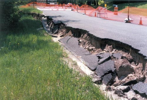 Photograph of the scarp displacement extending into the street near the right flank of the landslide. Introduction
Landslide Description The City retained GME Consultants, Inc., Minneapolis, Minnesota, to investigate the landslide and develop a remedial design to stop the movement. Soil borings found that the headscarp developed within sand fill which was placed in 1964 when the road was widened. The sand fill was very loose and extended as deep as 19 feet. This fill was underlain by naturally occurring, loose to medium dense glacially deposited outwash sand, which was supported by dense silt at a depth of about 45 to 49 feet. In an attempt to evaluate the depth of the failure surface, inclinometer casings were installed within hand auger borings drilled into the slide mass. Inclinometers consist of internally-grooved PVC pipe, within which is inserted a special electronic probe that measures verticality at specific points within the casing. A number of readings were taken over time and compared with the initial base-line value to evaluate movement and the potential depth of sliding. From this monitoring it was deduced that the landslide was not a shallow, surface-type failure, but rather a deep-seated failure.
Remedial Measures Although excavation of the upper portion of the landslide and replacement with lightweight fill would be beneficial in reducing the driving moment of the landslide, the apparent deep-seated nature of the slide would have warranted a rather deep subcut and replacement. Stabilization by anchored sheet pile retaining wall construction would have required the wall to have substantially long anchor tiebacks to resist the driving force of the landslide. In addition, the installation of the anchors within the rather steep, heavily wooded, river bluff would have been difficult. Buttressing the toe also would not be feasible since this would have destroyed a number of trees and would not have been aesthetically acceptable. The hydrostatic groundwater surface was deep, at slightly higher than the river elevation, but the control of other subsurface water sources, mainly from buried utility lines, would play an important part of the long term stabilization effort.
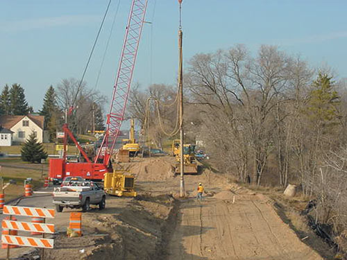
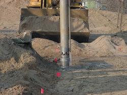
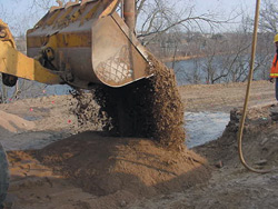
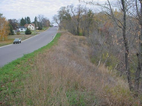
It was decided that a feasible method for controlling the landslide movement would be through subsurface stabilization and ground modification by a process known as “vibrocompaction.” The vibrocompaction process on this project used an 18 inch diameter vibrating probe having steel fins that increased the effective The vibrocompaction work was performed by the specialty geotechnical contractor, Hayward Baker Inc., Chicago, Illinois. Prior to stabilization, the head of the landslide was subcut up to about 10 feet, in order to relieve some of the landslide driving force during remedial construction, and to form a working bench. A 36 foot wide by 234 foot long bench with a grid of 135 compaction centers formed the area of stabilization. The compaction centers were spaced 9 feet on center. The effective compaction radius around each point is typically about 2 to 2.5 times the probe diameter, or on this project about 5 feet. The probe penetrated to depths of 30 to 40 feet below the working grade. Peak amperage draw of the probe was measured by an ammeter at the ground surface, and was used to monitor the densification process. In general, a 40 foot deep probe took about 30 to 40 minutes to complete. During compaction, a clean, coarse sand backfill was added from the ground surface to compensate for the reduction in soil volume resulting from the densification process. The densification was performed to increase the shear strength of the in-situ sand and achieve a calculated factor of safety of at least 1.3 with respect to the deep-seated stability of the landslide. Check borings were drilled and Standard Penetration Tests (SPT) were performed, along with electronic Cone Penetrometer Test (CPT) soundings, to evaluate the effectiveness of the vibrocompaction process. The results showed that the vibrocompaction effectively increased the shear strength of the sand to an acceptable level. Pre-construction SPT N-values within the loose sand fill were 2 and 3; post-densification N-values within the same zone of sand fill increased to between 11 and 28. To monitor ground vibrations away from the construction site, self-recording seismographs were placed near adjacent residential structures. The closest house was located about 60 feet from the vibrocompaction area, however all recorded vibrations were below a level established by the U.S. Bureau of Mines for potential damage to residential structures. As part of the vibrocompaction work, the City storm water pipe and river outfall was replaced in order to eliminate the source of subsurface water infiltration from the originally damaged pipe. After completion, the road was reconstructed and the site was restored to final grade by placing additional compacted sand backfill and surficial erosion control treatment. The work area was fully re-vegetated using a seed mixture of 52% crownvetch, 22% perennial ryegrass, 18% creeping alfalfa and 8% birdsfoot trefoil, with a MnDOT Specification 3885 Category 3, double-sided net and wood fiber erosion control blanket. The vibrocompaction and site restoration work was completed during the fall of 2001, below
Conclusion For more information, contact Gregory R. Reuter, P.E., P.G., Principal Geotechnical Engineer, GME Consultants, Inc., 14000 21st Avenue North, Plymouth, MN 55447, (763) 559-1859, Fax. (763) 559-0720, e-mail: greuter@gmeconsultants.com. |
©2003 - 1998 Land and Water, Inc.