Restoration of Urban Habitats:
|
|
|
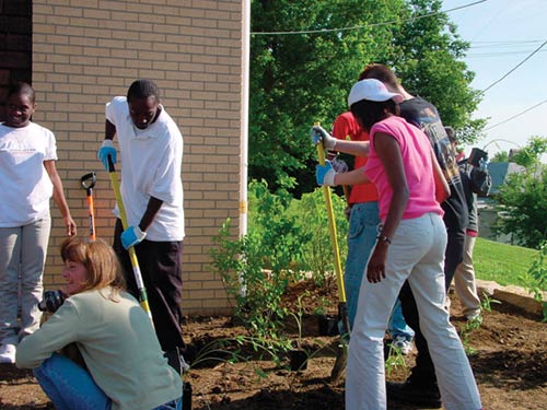
Development patterns within the 3000 square mile Kansas City metropolitan area are greatly impacting the existence and function of natural systems. This article will focus on how communities throughout the Kansas City region are stepping up to the challenge of understanding, protecting, and incorporating natural resources into development and stormwater management. By including natural resources within the development process with the same weight as infrastructure planning, communities will be better able to reach a balance between the economic, social, and environmental aspects of growth management. Stream inventories like the Kansas City Stream Asset Inventory Phase I, used in conjunction with other regional initiatives (Kansas City Metropolitan Natural Resources Inventory and the Kansas City Region Green Infrastructure), will provide planners with the tools and strategies critical to successfully manage stormwater, prevent flooding, and provide healthy communities in the future. Impacts of Urbanization For the same level of urbanization, streams with intact riparian woodlands have been found to have higher biotic diversity than those that do not. Stream degradation and channel instability due to more frequent bank-full flooding, higher peak discharge rates, lower dry-weather stream flows, and loss of instream (pools & riffles) and streambank habitat structures, can occur at levels of imperviousness as low as 10%. At levels of imperviousness of 25% or more, few if any streams can support diverse aquatic insect communities due to increased turbidity, toxicity, salinity, and decreased dissolved O2 (Wenger, 1999). KC Community Initiative
All of the steps within this three-tiered system are critical to providing planners and other decision makers with the necessary strategies and tools to integrate the natural environment and the human environment in a healthy and balanced manner. By implementing short-term and long-term guidelines for resource protection, the biological health and function of streams, rivers and other natural resources will be maintained and improved throughout the region.
KC Inventory Process
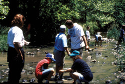
The rapid stream assessment methodology used for this project has progressed through a development and testing process initiated with the City of Lenexa’s Stream Assessment and Natural Resource Inventory Project (December 2001). Methodology for future stream asset inventories will further refine data collection by integrating GPS units. Preliminary field reconnaissance consists of the following characterizations:
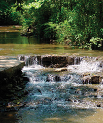
Field data collected is downloaded into an Excel spreadsheet for scoring and analysis. The stream characterization factors described above are given numeric scores based on USDA scoring methods. The score values are then weighted using the professional knowledge and judgment of field biologists involved in this project. The numeric score then provides the basis for classifying the stream segments into one of the following types. Type 1 - Generally described as the highest quality naturally occurring stream with little negative impact. Erosion and sedimentation is low, water quality indicators are positive and the surrounding riparian zone is a healthy, mature, succession woodland or other high-quality environment. Type 2 - This type of high quality stream may have some down or side-cutting, however, bank and bed composition (bedrock) assist in keeping the impact low. Water quality is generally good and the riparian zone is largely intact, although vegetation may be altered from that of a typical native plant association.
Type 3 - The riparian corridor is still restorable although deterioration is much more noticeable. While some remnant plant associations may be present, overall vegetative canopy cover is comprised of immature tree species. The potential for restoration exists although erosion and sedimentation can be greater than desirable. Type 4 - Impacts are greater on this low quality stream type with significant indicators of bank erosion and sedimentation present. The adjoining riparian corridor may be intact but vegetation is not representative of a native plant association. Type 5 - The channel in this type is the most changed and of the lowest quality. The riparian corridor is impaired to the point of providing little protection or benefit, and erosion and sedimentation indicators are significant. Water quality is questionable with noticeable phosphate and nitrate loading (large algae blooms). KC Inventory Results Studies show that a disproportionate amount of damage is done to stream quality during the relatively short period of active site development. Field observations indicate the existence of turbidity and sediment plumes attributable to development within the watershed. Cumulative downstream impacts of sediments and other pollutants are a significant contributor to water quality degradation in the study area. Unless proper erosion and sediment control practices are enforced as development occurs within the watershed, these cumulative impacts will increase the negative impacts on water quality and aquatic systems. KC Inventory Recommendations
City Planning staff plays a pivotal role in protecting the city’s natural resources in that they are the “first line of defense” in making land use recommendations and then reviewing development proposals on a site-by-site basis. The information contained here will guide the preservation thought process so that the most effort is spent protecting the most valuable assets. This information should be shared with the development community as early as possible in the design process so the private sector becomes a partner in preservation with the City. City decisions impact stream stability and water quality in three primary ways; land use planning/regulation, site development regulations, and design standards for public infrastructure. Recommended resource protection strategies relate to each of these areas with the primary goal of allowing development while retaining the existing, working natural systems. This goal can be achieved through protecting and retaining high quality natural resources, using natural systems such as vegetation to return stormwater to the soil rather than continuing to rely on structural storm drainage solutions, and managing precipitation as close to where it falls as is physically and economically possible. Improving stormwater management is often seen as a site issue rather than a larger scale planning issue. When the objective is to protect and retain high quality natural resources, however, the process begins with conservation– sensitive land use planning. There is a direct relationship between land use intensity and resource degradation. KC Regional Initiatives
This plan will form a key component of all local and regional planning efforts related to such factors as land use, economic development, transportation, water resources and air quality. Over the long term, beyond the scope of this grant, project goals would expand to create a regional framework for an interconnected, landscape scale conservation and restoration. The Kansas City Region Green Infrastructure Project is another regional initiative sponsored by MARC. The vision of this initiative is to create and implement cost-effective green planning and design. Increasingly, communities have begun to reevaluate the ways in which they develop. They simply cannot resort to conventional approaches and expect different results. Communities have long understood the need for infrastructure, like water and sewer lines, power lines and roadways. With strong support for “MetroGreen” in the Kansas City region, communities now recognize the value of open and green spaces. Many communities increasingly appreciate the importance of “green infrastructure,” - a planned, managed, interconnected network of natural areas like waterways, wetlands and forests; conservation lands like greenways and parks; and adjacent working lands like farms, ranches and corporate lands. The primary goals of this project are to improve stormwater management through the use of natural systems while creating successful partnerships across political boundaries. Promising designs and management strategies are being demonstrated on selected sites within the metropolitan region through large-scale municipal and county level projects and smaller scale educational demonstration projects. Summary
The Stream Asset Inventory project was funded through the City of Kansas City Planning and Development Department, using the consultant team of Patti Banks Associates (prime), Applied Ecological Services, Inc., Taliaferro & Browne, and Tetra Tech EMI, Inc. (subs). For more information, contact Laurie Brown, Conservation Ecologist, Patti Banks Associates, The Waterworks Building, 201 Main, Suite 201, Kansas City, Missouri 64105, Ph: (816)756-5690, Fax: (816)756-1606, Email: lbrown@pbassociates.com |
©2004 - 1998 Land and Water, Inc.