
Features Available Online
Loess Hills Residential Development Retains Rain
by Jason Johnson, Public Affairs Specialist, USDA Natural Resources Conservation Service
A one-of-a-kind residential housing subdivision called Woodfield is developing in southwest Iowa, near Glenwood along the Loess Hills Scenic Byway. Alfred and Brenda Beier purchased the 175 acres of rugged, overgrazed, highly erodible loess hills pasture in 2000. Later, the Beiers invited Ed and Ruth Cambridge to form the investment team Oak Ranch Development. They are developing Woodfield in four phases. The first phase is underway, which includes 20 acres in lots for 42 homes and 20 acres of open green space. Their goals include minimizing soil disturbing activities during construction and permanently managing storm water to protect water quality with low impact development (LID) practices that infiltrate water on-site.
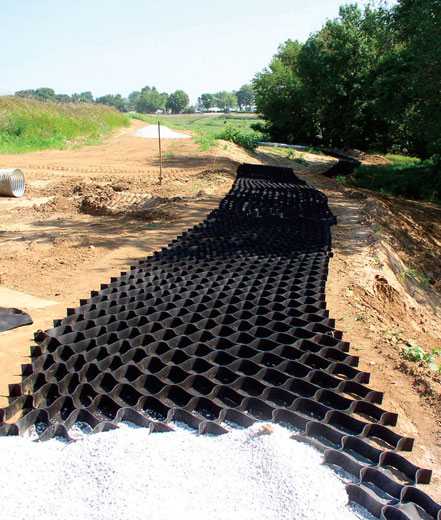
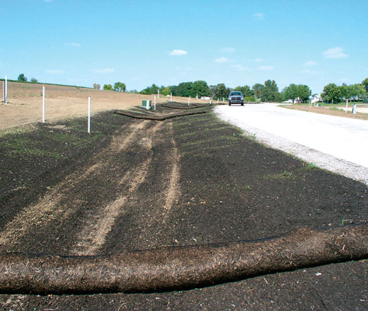
About 20,000 feet of pervious walking trail is planned for the entire Woodfield subdivision.
A geoweb vinyl grid lies on top of a geoweb fabric. The grid holds open grated rock in
place. The trail will infiltrate storm water runoff. Photo credit: Rich Maaske, IDALS-DSC.
LID is an ecologically friendly approach to land development and storm water management. This approach emphasizes site design and planning techniques that retain water on-site and mimic the natural infiltration-based, groundwater-drive hydrology of our landscape.
Loess (pronounced "luss") is German for loose or crumbly. The Loess Hills are rough and jagged, the result of erosion by the very elements that created them, wind and water. Loess soils form stable surfaces when dry, but wet loess soils are very susceptible to collapse because a lack of clay particles, which normally bond soils together.
Minimal Disturbance
To minimize disturbance of the loose, crumbly loess soil, Woodfield is designed in a way opposite of typical residential subdivisions. Instead of grading the entire site, building homes, then planting and seeding trees, shrubs and grass last, the team designed Woodfield to fit the existing landscape to reduce the amount of grading needed and land exposed to erosion.
Rich Maaske, an urban conservationist with the Iowa Department of Agriculture and Land Stewardship-Division of Soil Conservation (IDALS-DSC), says minimal disturbance is all about keeping cover on the soil. "The developers at Woodfield used the landscape to fit their development plans, instead of shaping the land to fit their purposes," he said. "They reduced the potential for large quantities of soil movement and the associated ramifications."
Maaske has worked in the Loess Hills region for more than 30 years. In the last ten years he has seen several conventional residential developments built in the Loess Hills, each creating storm water management and erosion control problems.
"Counties, cities and developers need to pay close attention to how and where developments go in the Loess Hills," says Maaske. "The Loess Hills are beautiful when they are stable with cover on them. Low impact development (LID) and minimal disturbance should be the standard. Green sells. Brown doesn't."
Phased Grading
Wayne Petersen, urban conservationist with the USDA Natural Resources Conservation Service, says grading in phases is important because it opens up only a portion of a site at one time. "Grading is completed, vegetation is seeded, and erosion control practices are in place before the next phase of grading is started," says Petersen.
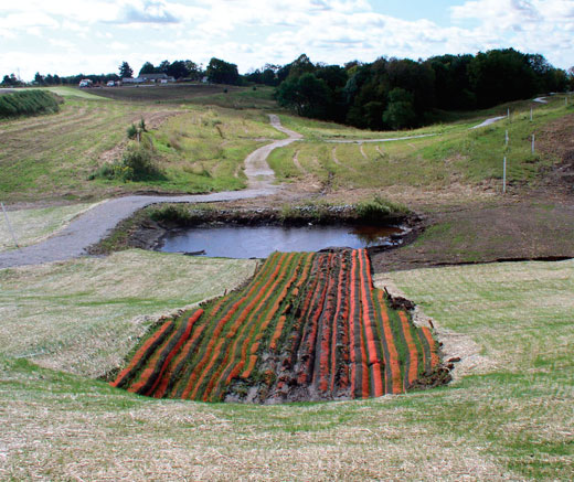
Streets are one of the few impervious surfaces at Woodfield. To capture storm water
runoff from streets, a road tube outlets water to compost-seed Filtrexx Soxx™ that reduce
flow to a temporary sediment basin. There is now a permanent infiltration trench in place.
Photo credit: Rich Maaske, IDALS-DSC.
Woodfield lots are located on hilltops, roads are placed on the contour and erosion-reducing agricultural conservation practices such as terraces are left alone, when possible. Additional trees, bushes and native grasses were planted and seeded in 2002, five years before the first home was constructed, to provide vegetative cover, windbreaks and privacy.
Cambridge says it is his goal to show other developers and investors that infiltration-based, low impact developments are not only environmentally-friendly, but economically feasible. "There is certainly less grading and less long-term maintenance involved with low impact developments," says Cambridge.
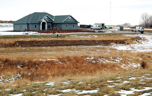
Homes in Woodfield are located on hillsides and ridges, leaving rugged terrain below as open space filled with native grassses and trees.
Notice that terraces, once built to reduce soil erosion on agricultural land, were kept in place. Photo credit: Jason Johnson, USDA-NRCS.
LID Practices
Most subdivisions are "curb and gutter", where rainwater flows to storm sewers to be flushed into our streams and rivers, along with pollution from roads and yards. In contrast, the goal at Woodfield is to direct water to infiltration-based storm water management practices where it is absorbed on-site.
"Here, we want to hold the water on-site, and we very seldom have water leaving the site," says Maaske.
One of the most visible Woodfield LID practices is grassed swales, which replace storm sewers. The grassed swales were seeded and then protected with a rolled erosion control blanket. High levels of organic matter in compost absorb rain and help retain water on-site. Swales are flatter than a typical road ditch (with a grade of less than 1.5 percent) to prevent gully erosion. Roads were built on the contour and direct water to the roadside grass swales.
Other LID storm water management practices at Woodfield include:
- Native Landscaping – About 30 acres of the entire 175-acre Woodfield development is native plants, with a root system that holds water like a sponge.
- Pervious Walking Trails – Phase one includes 6,000 feet of rock walking trails, built on the contour, utilizing geo-grid with a four-inch base that absorbs storm water runoff.
- Infiltration Trenches – Woodfield currently features two infiltration trenches. These are excavated trenches backfilled with a coarse stone aggregate and organic matter allowing temporary storage of runoff. They help surface runoff infiltrate into the surrounding soil.
- Rain Gardens – Rain gardens will be built and promoted by Oak Ranch Development. These are concave gardens featuring native vegetation strategically located to capture runoff from roofs, driveways, patios, and streets.
- Permeable Paving System – A few homes at Woodfield will feature special driveways with modular concrete paver blocks. This system allows water to infiltrate into soil and groundwater below substructure layers of limestone.
To help offset the cost of LID storm water management practices, Oak Ranch Development received a grant in excess of $300,000 from the IDALS-DSC Watershed Protection Fund. "Rich (Maaske) approached me early on about the development, and then he initiated the state grant," says Cambridge. "Without the grant, we wouldn't have been able to do the pre-construction plantings or walking trails."
Erosion and Sediment Control
Woodfield not only incorporates storm water management practices, but erosion and sediment control practices as well. Erosion control can be achieved by minimizing land disturbing activities and maintaining vegetative cover. Sediment is the number one pollutant of Iowa's surface waters. Sediment control involves trapping detached soil particles that are already moving from the erosion process.
One of the many distinctive storm water management practices at Woodfield is grass
swales, which substitute for traditional storm sewers. The swales were seeded with compost
to absorb water. To prevent erosion until vegetation is established, compost socks
were applied. Photo credit: Rich Maaske, IDALS-DSC.
Common, effective erosion control practices at Woodfield:
- Phased Grading – To reduce the amount of land exposed to erosion, developments should be designed to fit the existing landscape. This saves money by minimizing the amount of required grading. Oak Ranch Development investors purchased the land in 2000. A controlled burn of the area followed shortly after. Some grading took place prior to a native grass seeding and native tree and shrub planting in 2001 and 2002. Not until 2007 were roads built on the contour and the first home established. When homes are built, only that lot is disturbed and each one has its own erosion and sediment control plan.
- Vegetative Establishment – The best way to control erosion is to establish vegetative cover. Temporary vegetation with fast-growing annual species is an economical way to stabilize a construction site until permanent vegetation is established. Mulching or compost blankets should always be used with temporary or permanent seeding. At Woodfield, compost blankets were used in the bioswales to better absorb storm water runoff.
- Rolled Erosion Control Products (RECPs) – Mats or blankets of organic or synthetic materials applied to the soil surface protect disturbed areas from erosion, until cover is established. They are particularly effective at controlling erosion on severe slopes or areas of concentrated flows. Some grading took place prior to any homes being constructed. RECPs were used on slopes to hold the soil in place.
Common, effective sediment control practices at Woodfield:
- Compost Socks – Mesh tubes filled with biologically active composted material or mulch that slow and filter water to capture and degrade pollutants transported by runoff. They are placed at the top of slopes and on the contour across slopes to intercept and treat sheet flows. One of the areas compost socks were most effectively utilized in the pre-construction phase at Woodfield was below a tube that collected water from the newly constructed roads, one of the only impervious surfaces at Woodfield. A set of seeded compost socks effectively absorbed any storm water runoff before being outlet to a temporary sediment basin.
- Sediment Control Basins – The three sediment control basins, or ponds, located below the phase one site serve as sediment traps during construction and will serve as permanent water features to help manage storm water when all development is complete.

For more information about low impact development, call Rich Maaske at the West Pottawattamie Soil and Water Conservation District at (712) 328-2489.